
Summer Sizzle Builds Across the Central U.S., Then Heads East Through the Holiday Weekend
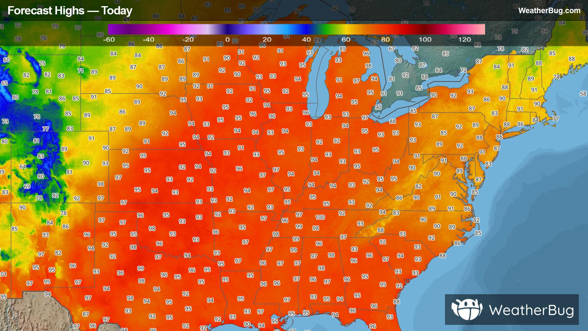
An upper-level ridge will continue to strengthen over the Great Lakes and Ohio Valley today. As a result, those summer-like sweltering temperatures will be out to play in the Plains and Midwest. The bullseye for the highest temperatures will also shift east to the Midwest and the Mississippi and Ohio valleys, creeping into the Eastern U.S. Temperatures will peak in the low to mid 90s, but will feel anywhere from 100 to 110 degrees. Some isolated locations may even reach a heat index of 115 degrees.
This expansive area of hot temperatures will reach the Eastern Seaboard by Wednesday. Residents from the Southeast all the way into southern New England will be feeling the heat at least through Friday thanks to high pressure taking hold over the East. Peak temperatures during this time will be as low as the mid 90s to as high as the low 100s. With elevated humidity also expected, heat indices will range anywhere from 100 degrees to as high as 115 degrees. Unfortunately, nighttime low temperatures likely will not drop below 70 degrees, leading to little relief from the intense heat.
Extreme Heat Warnings stretch from western Wisconsin and central and southern Minnesota into Missouri, including the St. Louis metro area, and northeastern Kansas. There is another pocket in southwestern Michigan into northern Indiana and northwestern Ohio as well as southeastern Missouri into southern Illinois, western Kentucky and central Tennessee. Widespread Heat Advisories are in effect from southwestern and central Minnesota to northern Wisconsin as well as in eastern South Dakota, eastern Nebraska, eastern and central Kansas, northeastern Oklahoma, southwestern and northeastern Missouri, central and eastern Arkansas, northeastern Louisiana, northern and central Mississippi, western Tennessee, northern and central Alabama, central and southern Georgia, northern Florida, central Kentucky, northeastern and central Illinois, central and southern Indiana, and northern and southwestern Ohio.
The Twin Cities, Des Moines and Iowa City, Iowa, Milwaukee, Chicago, Indianapolis, Kansas City, Mo., Omaha, Neb., Tulsa, Okla., Memphis and Nashville, Tenn., Louisville, Ky., Topeka and Wichita, Kan., Pine Bluff and Jonesboro, Ark., Jackson, Miss., Birmingham, Ala., Grand Rapids, Mich., Atlanta, Cleveland, Cincinnati, Atlanta, and Tallahassee and Orlando, Fla. are included.
Extreme Heat Watches have also been issued for eastern Michigan, central and eastern Pennsylvania, New Jersey, eastern Maryland, Delaware, central New York to the Lower Hudson Valley and the New York City metro, Connecticut, Rhode Island, Massachusetts, western and southeastern Vermont, southern New Hampshire and southwestern Maine.
By the holiday weekend, this expansive high pressure system will weaken a smidge, but will stay centered over the Mid-Atlantic. As a result, elevated temperatures and humidity will refuse to budge for many over the Eastern U.S.
If you are in one of these areas experiencing unseasonably hot temperatures, it will be important to stay hydrated and cool. Avoid exposure to the sun from late morning into the early evening. Take frequent breaks in the air conditioning or shade. Eat and dress lightly. Use sun protection if outdoors. Never leave kids or pets unattended and remember to “Look Before You Lock!” Recognize the signs of heat-related illness.